

Shadwell Local History Society welcomes everyone who wants to participate in exploring the history and heritage of our local area.
For more information please contact: librarian@shadwell-library.org.uk or call 0113 2656450.
Access Statement: Unless indicated all sites are accessible / visible from the road or pavements. Any access limitations are outlined under each location description at the bottom of this map. Footpaths (indicated by a pink dotted line) have limited access (eg. stiles / uneven ground), and are not wheelchair accessible. Benches are indicated on the map. An accessible alternative to the site locations on the map is provided with what3words. The locations given are for site entrances where appropriate. Download the latest Android or iOS what3words app from https://what3words.com/products/what3words-app, or go to their online map by clicking the link provided for each site.
West End Trail
1. Domesday Book

1086 A small agricultural village which was unaffected by King William’s ‘Harrying of the North’. Subsequently the income from parts of Shadwell was given to the monks of both Kirkstall and Fountains Abbeys.
2. Library, built 1814

Originally a Wesleyan Methodist Chapel, becoming a Sunday School for the New Chapel (opposite) in 1892 and a City Library from 1932. In 2013 it became a Community Library and Arts Centre.
Access: small step (8cm) into the library area; no fully disabled toilet (the toilet is raised with grab rails).
what3words: gallons.insect.total
3. Colliers Lane: view to the west
This was one of the common fields where crops were grown. You can see the waste /woodland on which the villagers had common rights to graze cattle and gather fire wood. ‘Ridge & furrow’ plough lines can be seen in the field adjacent to Main Street.
what3words: hungry.head.dogs
4. Colliers Lane field system ‘Ridge and Furrow’
Shadwell followed the conventional layout of a medieval manorial village – tofts, crofts, common fields, waste land, common grazing land and the demesne lands of the Lord of the Manor.
5. Bluebell Wood or Pitts Wood/Quarry

Beneath your feet in Shadwell there is much good quality building sandstone. This was quarried here at Bluebell Wood.
what3words: quick.backs.crazy from the north; lives.inches.colleague from the south
6. Colliers Lane history
The track in front of Bluebell Wood is part of an ancient roadway leading from Leeds to Harewood. It came up Dibb Lane, Elmete Lane, over Leeds Golf Club and up to Shadwell before going on to Brandon, Wike and then Harewood.
what3words: then.normal.notice
7. Red Lion, built early 1800s

There were two wells close to the Inn with beer likely to have been brewed on site. In 1814, the owner sold land to the newly formed Methodist Church. In the early1900s the landlord was a keen cricketer, acquiring the field opposite the Inn; the successful club was based here for 100 years before it moved to Brandon Crescent.
Access: Accessible site, but no separate disabled toilet; grab rails in women’s toilet but not men’s.
what3words: reply.fakes.wounds
8. Holywell Lane, built in 1874

Long through terrace houses were built for Eccup Reservoir workers, known as ‘Barracks No. 1’. Soon after they were converted into back-to-back houses, becoming very over-crowded (some housed over 14 residents). The three storeyed house in the middle of the terrace (and the one behind it) were built later.
what3words: tools.dairy.assets
9. Recreational Centre, Holywell Lane
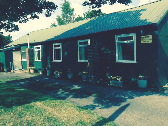
Originally built as a Scout Hut in 1930, it was deemed to be unsafe before WW2 and was used as an engineering works. The Amateur Dramatic Society operated successfully from this building until the 1960s. Now it functions as a Community Centre.
what3words: solo.craft.hips
10. Holywell

The porous sandstone upon which most of Shadwell is built is underlain by a thick layer of impervious clay– which is why there are so many wells in the area. The ‘Holywell’ is a pond which can be spied through the hedge of Spencer House. It was said bathing in or drinking the waters from the Holy Well would cure all sorts of diseases.
what3words: grades.hopes.sparks
11. Yarm Cottage, built in the 1870s
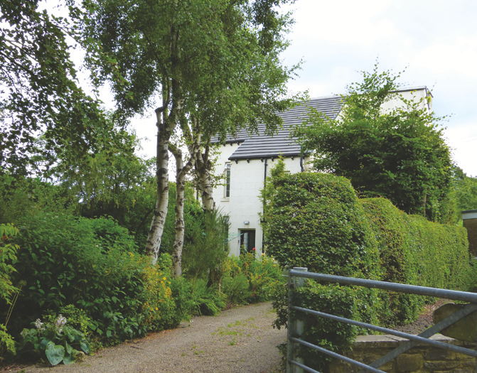
The majority of its garden was later acquired by the then owner of Spencer House. Edmund Bogg (1850–1931) was a prolific writer of north country guides and local history. Famous for having started the Savage Club in Leeds in 1891, a hedonistic group with a healthy interest in the Red Indians.
what3words: played.gaps.clay
12. Temperance Cottage, built in 1756

Built for a stonemason who quarried nearby Dan Quarry. From 1887 to 1930 it was a Temperance Hotel (competing with the Red Lion, but no alcohol!). It was used for village fêtes, dances, wrestling matches; the field to the west was used for Sunday School treats and races. During WW2 it was used for fire watching.
what3words: wage.unrealistic.parts
13. Dan Quarry

One of at least 6 local quarries, all part of the sandstone beds which underlie the area. Originally part of Shadwell Moor, which was land available for use by the whole Village. When the land was enclosed in 1807, it was set aside as a public quarry and ‘awarded for getting stones, gravel and sand for building…’.
what3words: bids.driven.driver
14. Shadwell Stone
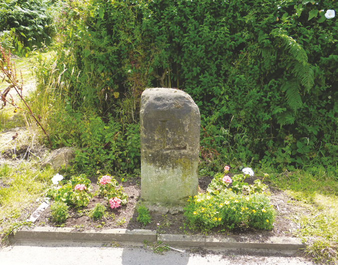
Marks the boundary between Shadwell and Slaid Hill, and shows the direction to Wetherby ‘W’ and to Leeds ‘L’. In 1998 it was dumped behind where the stone is now located. An observant local contacted the Village Lengthman, who spoke to a foreman at the Council and within 24 hours the stone had been restored to its present location.
what3words: newly.game.goods
East End Trail
15. Fish and Chips

In 1637 John Barrit obtained permission from the Lord of the Manor to erect this home for himself and wife Ann, hence the lettering over the door. One of the first houses to be built of locally quarried stone, most houses were built of timber, wattle and daub. Note the moulded door surrounds and the chamfered windows.
Access: No wheelchair access because of two steps, but food or drinks can be ordered from the footpath!
what3words: woes.radio.goods
16. Minster View

The towers of York Minster can be seen from here. Most of the house is a large Victorian extension to a late Elizabethan earlier stone building. In the early/mid 20th century it was owned by Colonel Henry Ludolf (who owned land on which Ash Hill/Ludolf Drive houses were built). He was to be seen riding in his huge motor car or perched on the top of his large horse. Henry was also an inveterate letter writer to the local press.
what3words: flank.funds.buck
17. Old Hall
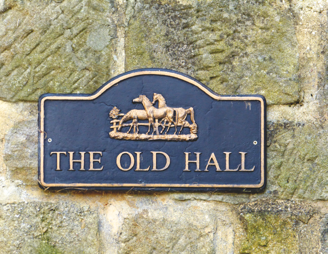
This property bears a date stone of 1706—it is quite possible that a part of the property will date back this far. The house was originally called ‘Shadwell Hall’ and the land holding until the late 19th century was very large, going up as far as Gateland Lane.
what3words: vivid.length.rarely
18. Village Green
The present Village Green is a shadow of its original size. It used to extend up as far as Gateland Lane. The area is still called ‘Stocks Hill’, where the Village stocks stood and petty criminals will have been temporarily ‘grounded’. The cottages which today front onto the triangular piece of grass were built at different times. 152 and 154 were built in the early part of the 19th century. The three cottages furthest from the farm were built in 1905 and the others were built between 1829 and 1900. At one time the Village Post Office was operated from 144.
what3words: hills.spins.view
19. Manor Farm

(Please note this is private property: please do not trespass.)
A typical late 18th Century farm-house, built by and still belonging to the Elizabeth Hastings Trust. Quite possibly part of the demesne lands belonging to the Lord of the Manor in the period after 1066.
what3words: scouts.acted.lofts
20. Chapel of Ease
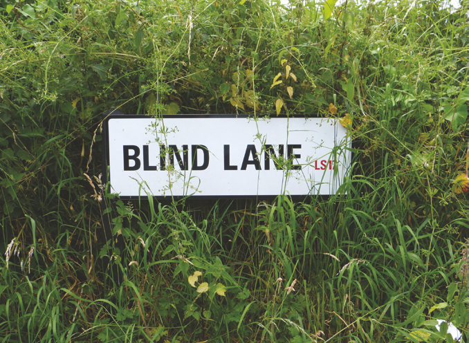
From before 1438 until 1842 the only Church of England place of worship was the Chapel of Ease, located where the redbrick bungalow is found on the lower portion of Blind Lane (formerly part of the Village Green). Because it was not a parish church, baptisms, funerals and weddings had to be carried out at the Parish Church of Thorner. The Chapel at times was ‘taken over’ by Dissenters and ultimately by the beginning of the 19th century the Chapel fell into disuse.
what3words: joined.trials.rainy
21. Dove & Pigeon Cote (Private land)
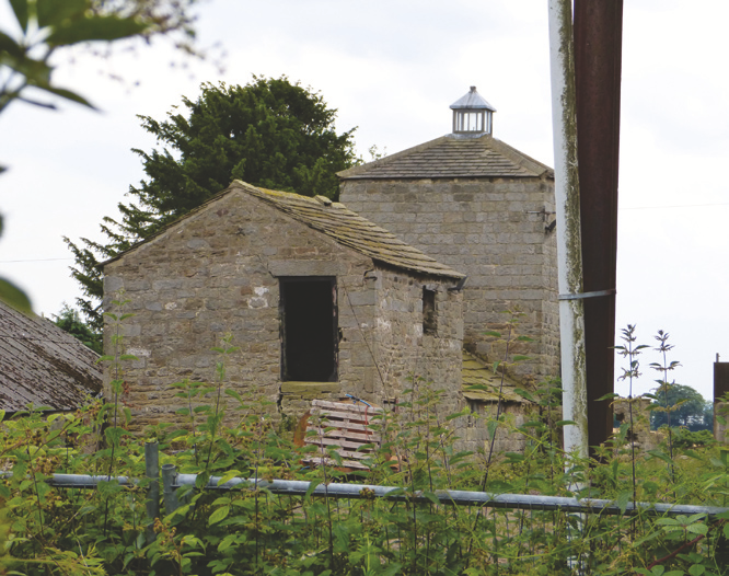
On tiptoe, with your back to the site of the Chapel of Ease, you will see a three storey building with a pyramid roof and restored glazed cupola on top. This was a late18th century pigeoncote, with probably a bull house on the ground floor. Pigeons and young pigeons (called squabs) were a very useful source of food , especially in winter, when there was little fresh food available. The pigeon dung was used as a fertiliser.
Access: Views are obscured by vegetation. Only partially visible from single track Lower Blind Lane. Hard to see from a wheelchair.
what3words: pizza.hiking.bulb for best public view
22. Site of Pottery Kiln
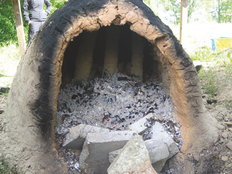
(Private land. Do not trespass.)
Between Gateland Lane and the Farm buildings is the site of a 16th century three flued pottery kiln. In 1977 a local resident noticed shards of pottery in a newly ploughed field. Investigations took place ; the kiln and a large quantity of pottery was exposed. The pottery went to Leeds Museum and the Kiln was covered once again with topsoil. The base of the kiln was found intact, along with walls up to a metre high.
Access: Kiln is no longer visible or accessible. Lower Blind Lane is a single track road.
what3words: purple.sparks.shut
23. Pinfold

In medieval times, when animals strayed onto the Common Fields (and perhaps ate the crops) the Pinder’s job was to round them up and put them in the Pinfold. They’d be released to their owners upon payment of a fine. The boundary wall of the first house in Hastings Court was a part of the walled area which held the animals. Hastings Court was named after Lady Elizabeth Hastings, a wealthy landowner, who died in 1739. To this day Manor Farm and other farm land in Shadwell belongs to a charity set up in her name.
what3words: hammer.faced.wipe
24. St Paul’s Church (Grade II Listed)
The new vicar to Thorner Parish in 1839 was concerned that his flock in Shadwell had lost its Chapel of Ease; the walk to Thorner was a long one. Arrangements were made to build St Paul’s, which opened in 1842. Architect Robert Chantrill had just completed Leeds Minster. The burial ground was acquired in 1861 and in about 1870 Shadwell became an independent parish. What is now known as ‘The Old Vicarage’ was built for the vicar in 1872.
Access: Disabled access to the church and toilet; however this is not a disabled toilet.
what3words: fence.elder.ears
25. Rose Cottage

Rose Cottage was built on the site now occupied by the first house in Avon Close. This was a boarding school for boys which opened in July 1842. The good clear air was its main selling point. The teacher was a Mr Snowdon, who had been a ‘Classical and Mathematical Assistant to a Reverend Gentleman’. In 1850 there were 13 boarders aged 7 to 16. In the latter part of the 19th century it became a boarding school for girls. The school eventually became a residence before being demolished in 1967.
what3words: ships.wiser.moral
26. St Paul’s Shadwell Village Hall

In 1874 Grove Cottage was sold for £240. Land for the Second National School was purchased for £60 from the Elizabeth Hastings Trust and the new school was built. The very young children were housed in the small room to the right of the entrance. All the other children were taught in different parts of the main hall. The School closed in 1957. The present Shadwell Primary School did not open until 1967.
Access: Disabled access to the Hall and toilets. There is also a separate disabled accessible toilet.
what3words: aware.feels.others
27. Grove Cottage: the site of Shadwell’s First National School
In 1847 Stephen Nicholson (of the Mansion in Roundhay Park) was the Lord of the Manor and he gave land for the building of Shadwell’s first National School, for the education of poor children to be educated in line with Anglican principles. The teacher was to be employed by the Vicar of Shadwell. By 1874 there were 220 children in Shadwell and a larger school was needed, and the school was rehoused in what is now the Village Hall.
what3words: loving.silk.civic
28. The Pumping House

Until 1912 Shadwell’s sewage system was very basic – mostly toilets linked to cesspools (which often overflowed) or simple closets, with ash added to the waste. This mix was collected by a night soil man with his horse and cart. The contents were dumped in fields known as Ash Hills. The main reason Shadwell joined Leeds was to get a proper sewage system. The pumping station was built to pump sewage from low parts of the village to the highest point on Main Street. From here gravity would ‘take over’ and the sewage flowed downhill towards Roundhay.
what3words: heat.bared.force
29. Shadwell Methodist Church

There have been Methodists in Shadwell since the late 18th century. Opened in 1814, the original Church is now the Library. The congregation increased through the 19th century and the larger Church building of today opened in 1892. It continues to be a place for worship and community activities.
Access: Wheelchair access throughout; wide doors. Fully fitted disabled toilet and baby nappy changer unit.
what3words: union.usual.tender
